Garmin XT, is there a detour button ?

I just zoom out on the map and manually navigate back to the magenta worm after the blockage. This is on a Zumo 390 but would apply to any device.
 
I just zoom out on the map and manually navigate back to the magenta worm after the blockage. This is on a Zumo 390 but would apply to any device.
Possibly, but there used to be a dedicated detour button on the 660 which was very useful
 
Possibly, but there used to be a dedicated detour button on the 660 which was very useful

there is on the 390 but I have never used it ... I like old school navigation using a map. I did it for decades having navigated for my dad in his truck in the late 1960s so was quite good at it by the time I passed my test at 17. Unless your device has live traffic updates it isn't going to know how to calculate an accurate deviation anyway. It will just guess based on a parameter you give it but might drop back the wrong side of the blockage.
If you want a reliable deviation I suggest you stop, get your phone out, have a look at Google Maps. This might show the precise location of the restriction so you can add a suitable waypoint to the route to circumnavigate the blockage.
 
You can mark a closed road junction. Or if on a route skip next waypoint (if you have them set up)
 

Garmin XT, is there a detour button?​


If so how do I find it please.?


You can access and use the detour feature on your Garmin zūmo XT by opening the active route menu on the map screen and selecting your preferred distance or road bypass. [1, 2]

How to Enable Advanced Detours
    • Tap Settings from the main menu.
    • Select Navigation.
    • Turn on Advanced Detours. [1, 2]

How to Use the Detour Button
    • While navigating an active route, tap the menu button (three lines) in the bottom-right corner of the View Map screen. [1, 2]
    • Choose Edit Route or select your detour criteria. [1, 2]
    • Pick from the available options:
      • Distance-based detours: Choose 1/2 Mile, 2 Miles, or 5 Miles to route around a problem area and rejoin your path.
      • Road-specific detours: Select Detour By Road(s) in Route to pick specific upcoming roads you want to avoid. [1]
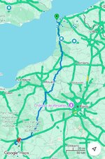
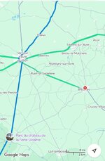
The best guide to closed roads is arguably Google Maps, though it is not infallible.

You can transfer a Gamin GPX route into My Google Maps. If you want to check a route for closures before you set off, it does work:

IMG_0912.jpegIMG_0913.jpeg

How do I mark a closed road then please.

Adding a Custom Road Avoidance
    • From the main menu, select Settings > Navigation > Custom Avoidances.
    • Select Add Avoidance (if prompted), then choose Add Avoid Road.
    • Pan and zoom the map to find the road you want to skip.
    • Select the starting point of the blocked section on the map, then select Next.
    • Select the ending point of the section to avoid, then select Next.
    • Select Done. [1, 2, 3, 4]
Your zūmo XT will now route around that designated segment whenever possible. You can store up to 50 custom avoidances on the device, though keep in mind they may need to be re-verified or re-set after major map updates. [1, 2]
 
Last edited:
Go into the menu and look for "avoidances", you can just draw a box on the map showing the blockage and it will instantly re-calculate.

  1. Select Settings > Navigation > Custom Avoidances.
  2. If necessary, select Add Avoidance.
  3. Select Add Avoid Area.
  4. Select the upper left corner of the area to avoid and select Next.
  5. Select the lower right corner of the area to avoid and select Next.
    The selected area is shaded on the map.
  6. Select Done.

Just make sure you do not have a waypoint just the other side of a blockage - imagine you come to a closed road right in front of you, the way around it could take you miles out of your way, but if you had a waypoint just the other side of the blockage it will run you back around to just before that blockage and then turn you around to continue the journey.

Sometime it is as easy to zoom the map out and figure it for yourself, if not, just stop the bike and add the avoidance, then check you do not have a waypoint "behind" where the detour will bring you out - once it has re-routed you can see that by zooming out, if there is a waypoint back towards the block just hit the skip waypoint button.

Best to test it before setting off on a trip, do a little route locally to you, then pretend part way round you have hit a closed road and have a go at adding the avoidance. It is not hard.
 
Thank you all for the info.
I thought the unit was already linked to my phone so it would get road closures.
However, I’ll check all this out this weekend.
👍
 
I thought the unit was already linked to my phone so it would get road closures.

AI’s answer, which (somewhat worryingly, perhaps) draws part of its knowledge from UKGSer:

The Garmin zūmo XT connects to your smartphone via Bluetooth and the Garmin Drive app to receive real-time live traffic updates, including road closures and construction zones. [1, 2, 3]

How It Works
    • Data Connection: The device pulls live data over your phone's cellular connection and pushes it to the GPS unit. [1]
    • Automatic Rerouting: When a road closure is detected ahead, the unit will attempt to recalculate a detour, though users on UKGSer note that opinions are mixed regarding how clearly the device communicates or displays the exact closure point on pre-planned or BaseCamp-imported routes. [1, 2]
    • Quick Disappearances: The notification or visual indicator of the specific closure on the map can sometimes vanish quickly after recalculation. [1]

Setup Steps
    • Download and install the Garmin Drive app on your iPhone or Android phone.
    • Pair your phone via Bluetooth to the zūmo XT.
    • On the zūmo XT, go to Settings > Traffic and verify that the traffic checkbox is enabled.
    • Ensure your phone has active mobile data and cellular coverage while riding. [1, 2]
 
Thank you all for the info.
I thought the unit was already linked to my phone so it would get road closures.
However, I’ll check all this out this weekend.
👍
It won’t re-route you if there is a diversion and it ‘thinks’ it will still be quicker than an alternative route. As I found out last month trying to get north on the M1 after 21:00. Massive traffic jam near Nottingham, road closures further north, nice diversion through Durham. Didn’t help the A19 was also closed.
 
If you connect to the app and enable live traffic, it suggests detours and shows time saved or added.
 
AI’s answer, which (somewhat worryingly, perhaps) draws part of its knowledge from UKGSer:
Thanks Wapping , I’ve just done all that and I’ll try it out soon. But not today. After doing 1102 miles in a day I’m leaving it alone for a few days 😀
 
The "Live Traffic" is useful but far from 100% accurate, a local road closure that lasted ~2 days was still being showed on my device ~ 18 later. Not sure the data sourc(es) Garmin get the closures from or who is responsible for adding and removing such closures - my guess (for the UK at least) is local authorities, judging by how innacurate it is.

Same goes for heavy traffic, often it will show a red line for slow / stopped traffic where there is none, probably due to the blockage being quite short lived and it updating too slowly.

On a heavily congested road I used to commute on it would suggest a huge detour, instead of going ~2 miles in stop-start traffic which maybe takes 15-20 minutes, it came up with a 5-6 miles detour on roads I know would be pretty heavily congested and quite slow and almost certainly add 5-10 minutes to the journey, unless it shows a suggestion that saves me a LOT of time I ignore it.

The situation on the ground (road) can change quickly and too many times I have taken it's advice just to end up in a queue I was fairly certain was as bad, or worse, than the one it avoided.

But you will want to thank it the day it stops you driving past the last Motorway junction before a total closure due to an accident or similar.
 
The "Live Traffic" is useful but far from 100% accurate, a local road closure that lasted ~2 days was still being showed on my device ~ 18 later. Not sure the data sourc(es) Garmin get the closures from or who is responsible for adding and removing such closures - my guess (for the UK at least) is local authorities, judging by how innacurate it is.

Same goes for heavy traffic, often it will show a red line for slow / stopped traffic where there is none, probably due to the blockage being quite short lived and it updating too slowly.

On a heavily congested road I used to commute on it would suggest a huge detour, instead of going ~2 miles in stop-start traffic which maybe takes 15-20 minutes, it came up with a 5-6 miles detour on roads I know would be pretty heavily congested and quite slow and almost certainly add 5-10 minutes to the journey, unless it shows a suggestion that saves me a LOT of time I ignore it.

The situation on the ground (road) can change quickly and too many times I have taken it's advice just to end up in a queue I was fairly certain was as bad, or worse, than the one it avoided.

But you will want to thank it the day it stops you driving past the last Motorway junction before a total closure due to an accident or similar.
All these devices can only work on updates given to them and then fed into the system. I went to a hotel in deepest Dorset in the week. The road to the hotel was closed and the hotel sent out an alternative route. I plotted the route and used my route app to follow the route.

As an exercise I put the location separately into my Garmin (linked to my phone and live traffic), also Waze. None of the apps knew the road was closed. Didn’t try google maps.
 
Way too much drama on this thread.
If the road is closed, turn round and find another way.
 
If the road is closed, turn round and find another way.

There’s a lot of truth in that. I don’t think I have ever engaged the detour button, not least as road closures are generally (but not always) well signed.

It is though useful to know and understand how the detour button works.

:beerjug:
 
Used it once, and wished I had used it a couple of other times when I ended up at the side of the road zooming about all over the sat-nav map trying to figure out a way around it, then needing to stop and re-check.....

....But often, as I always have a track displayed, I can just zoom the map out quite a long way and figure out which roads adnd turnings to take to get back on track - and ensure I am indeed heading roughly the ight way to re-convene with my original route.

So plenty of options depending on the difficulty (perceived or real)


Back
Top Bottom