Kurviger or other navigation app

Despite decades wirking for the 'Top Telco in the world' for well over 4 decades I'm hopeless with technology unless it's very basic, I haven't a clue how to try to create a GPX file or how to move a pre-created one from one device to another. I gave up on Basecamp years ago, it's well beyond my severely limited capabilities.
As my Nav V is playing up I've recently bought a phone screen mirroring device with a view to utilising one of these motorcycle navigation apps.
I've had a look at Calimoto and Kurviger and the latter seems better suited to my lack of intelligence so I'm going to give that a go.
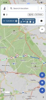
I've asked it to create me a circular route of about 100 miles from our house and will be trying that out shortly.
 
I've arrived at my destination.
What went well?
1) The route it set me was pretty good taking me down a nice mix of single track roads and B roads. It routed me along roads I've never been on and through villages I've never heard of let alone been through, despite living here for 50+ years.
2) There was a small amount of screen lag regarding where I was vs where it thought I was but only by 50 yards or so. Given that it was piggybacking off my phone I thought this was more than respectable.
3) Auto zoom was excellent.
4) E.T.A. proved to be pretty accurate. Initially I thought it was over optimistic but I arrived within a minute or 2 of the initial expected time, despite being a bit of a dawdler.

What don't I like?

1) The lack of an indication of the speed limit or my actual speed. Disappointing in an App. I'm paying for when Google Maps has this information despite being 'free'.
2) Does it have live traffic updates? I'm not sure but, again, Google Maps does.
3) Speed and distances are in K.M.H., I'll have a fiddle about with the settings later and see if I can change this.

So after a brief try the jury is out. Let's see how things pan out.

Edit: I also learnt that my Sena intercom isn't working. A quick search on the Internet suggest that after 6 years the battery needs replacing. Thus meant that, obviously, I can't comment on the vocal navigation instructions.
 
Last edited:
Well that didn't take long. I've been able to amend it to M.P.H. and show speed limits on the settings page. (y)

Edit: I've amended it again. This time to show speed limit and current speed.
 
How much does it cost?

I’m a tight get so been using ChatGPT for a rough route. Then letting Kurviger interpret it and just following the trace. No directions as such.

Would be nice to have live cameras like Waze.
 
About £27 for the full version. I like Waze but can't use it anymore for political reasons.
That's a good point about live cameras though.
 
Keep tapping around. You can’t break it.
Just as well as it's clearly a work in progress on my part.

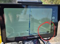
Having fiddled around with the settings I set a new route for home on the app on my phone, got on the bike and brought Android Auto up on the device only to be met with a screen which, whilst now showing my current speed had very little other information on.

1000091251.jpg
 
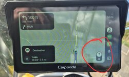
I switched off the bike, brought the route back up on my phone and all the information was on there. I switched the bike back on and Hey Presto! I had better screen information, everything I needed was there. Well, almost. The current speed limit was shown as a question mark, I assumed this would update once I got going or at the very least moved into a different speed limit but no, the question mark was all that I saw.

1000091252.jpg

Edit: Interestingly it was trying to route me back to the café I'd just left, possibly because I hadn't asked it to stop routing me there when I'd arrived, even though I'd created a new route. :nenau

As we said, it's (I'm) a work in progress.
 
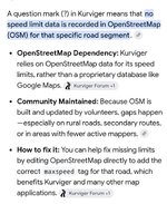
T'interweb shows this....

1000091264.jpg

I've signed in to OSM and it's right, there's no speed limit showing for that area. I can't figure out how to update it on my phone so I'll fiddle about with it on my laptop come the dark winter days.
 
Last edited:
Another thing I learnt today is quite how power hungry navigation apps are. It was a round trip of roughly 2 and a half hours. I set off with 48% charge on my phone, had 28% left when I arrived but a few miles into the return journey my phone died as it had no power left. I really should have taken a power bank while I'm experimenting.
Should I persevere I'll go down the Thunderbox route as advised by Wapping. (y)

Also the phone and Carpuride chat happily when the phone is behind me in the aluminium top box, this is a good thing as my tank bag's not fully waterproof.
 
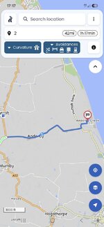
I've just looked at the route again. It would appear that had my phone kept working then speed limits would have shown further along the route.


This is the bit where I was getting the question mark....

1000091270.jpg

As you can see further along the route in the more widely used areas the speed limit shows on the map so would presumably have shown on my device.....

1000091272.jpg


Ignore the bit about the route no longer existing, I can't delete it, sorry.
 
I'm out again trying the Kurviger Application once more.
The speed limit thing is working though not to be relied on as it's not entirely accurate. I guess this is due to OSM not being updated when the local councils change the speed limit.
I started with 100% charge on the phone battery, am an hour in and have 78% charge left. I have the phone in the tank bag and despite the ambient temperature being around 17C the phone is very warm.

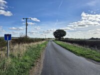
I've asked the app to do me a 100 mile circular route heading in a direction I never use. The roads have been a mix of single track and main roads, despite me upping the 'main road avoidability' setting to 80%.
I've deliberately 'missed' some turnings and the app has rerouted me without fuss, the only minor issue being total loss of navigation in an area with no phone signal.

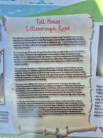
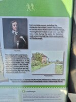
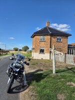
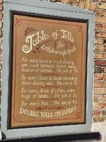
One unintended detour brought me to this fascinating little piece of local history....

1000091363.jpg
1000091364.jpg
1000091365.jpg
1000091361.jpg

1000091362.jpg
1000091367.jpg
 
the only minor issue being total loss of navigation in an area with no phone signal.

If you can download the maps and set the app to ‘offline’ navigation, that should never be a problem again….. or at least much less of one.

I use MyRoute, its maps downloaded and the app set to ‘offline’ navigation by default. It runs on a sacrificial iPhone, with no SIM card, so it can’t receive a phone signal, even if it tried.
 
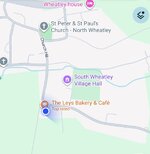
I was also directed past this place....
1000091380.jpg


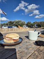
As it was time for a spot of lunch I called in for the most expensive bacon and egg cob I've ever had - £9.30. Delicious bacon but ruined by being in a Brioche Bunn, what is it with this latest Brioche trend nonsense? Bacon cobs should be in a floury bap, burgers should be in a burger bun, it's not difficult is it?

1000091374.jpg
 
Last edited:


Back
Top Bottom