Kurviger or other navigation app

If you can download the maps and set the app to ‘offline’ navigation, that should never be a problem again….. or at least much less of one.

I use MyRoute, its maps downloaded and the app set to ‘offline’ navigation by default. It runs on a sacrificial iPhone, with no SIM card, so it can’t receive a phone signal, even if it tried.
Thanks. I do have a spare phone and you can download partial maps on Kurviger so I'll give that a go if I continue with the app..
 
I started with 100% charge on the phone battery, am an hour in and have 78% charge left. I have the phone in the tank bag and despite the ambient temperature being around 17C the phone is very warm.

Yup, the phone is having to work pretty hard, processing data as you hoon, linking it to an app and then streaming it to a remote screen. And that’s before you consider what other apps you might have running (some hidden) in parallel or behind.

Besides not wanting to lose my main phone, it’s one of the reasons I use a sacrificial phone, as I have stripped out (deleted) just about all the apps on it. Not least, as I don’t need to know what the weather is like, nor listen to someone gibbering on.

I do though still power it, benefitting from even the most modest of vehicle’s surplus of electrical power, which otherwise goes to waste.
 
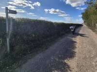
Despite setting the route to avoid unpaved roads I was directed this way....1000091382.jpg

Not ideal but as it was just me and no luggage I meandered down it. Although marked up as a Byway it was a wide road with no issues other than a pebbled surface rather than tarmacadam.
 
A successful day I reckon. Once again Kurviger.de has done what I asked of it and taken me along some lovely little roads less travelled. It seems to be generating routes that avoid larger towns despite being set to 'Curvier' routes, unlike my Nav V.
Next test will, I think, be a longer route to a specific place via 'Fastest route'.

Edit: 4 and a half hours in and despite also using my phone to write this up and take a few photos along the way my phone is still showing 31% charge.
 
The current speed limits are not always present (nor always correct) on assorted map / routing app’s, up to and including the otherwise highly detailed Google Maps.
Which kind of begs the question, if it doesn't know the speed limits how can it arrive at a fairly accurate E.T.A.? :nenau
 
Which kind of begs the question, if it doesn't know the speed limits how can it arrive at a fairly accurate E.T.A.? :nenau

It makes an educated guess, I guess.

You only need to look at the estimated time predictions for the same route on assorted app’s and / or even on different bods’ devices running the same app’s, to see that it’s not always uniform.
 
What is often useful, particularly for bids who maybe haven’t done so many longer rides, is to see how the estimated arrival time moves further and further away whilst they are stopped.

Some foik don’t seem to realise that, if you are averaging say 40 mph and you stop for an hour for lunch, that’s 40 miles ‘lost’ which has to be made up. Likewise, eventually, smoke stops, fuel stops, stops to take pictures (it used to be stops to look at a map and shake one’s head) all add up.

:beerjug:


Back
Top Bottom