Waypoints to Zumo

jjwill

Registered user
Joined
Aug 27, 2014
Messages
22
Reaction score
3
Location
London
I have added a number of waypoints in Basecamp. Is it possible to import just those waypoints into my Zumo XT as I may need to make routes up later?
 
Yes there are a number of ways to do this.

1.If you transfer the file as a GPX directly to the XT internal memory then the waypoints will appear as favourites.
2.If you transfer them to an sd card in the XT then you have to go to favourites top left hamburger Icon and import them into favourites from the sd card.

This works well for a smallish number of waypoints say <30. There are likely other favourites in that folder and larger numbers become unmanageable

3. For larger numbers of waypoints create a POI file using POI loader (Free from Garmin) you can then create your own categories of POI's and load these into a route or as a destination on the fly. This can enable things like proximity alerts and custom Icons/sounds for these POI's

 
This is my current list of Custom POI's

1792237271963.jpg

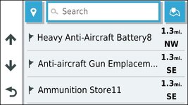
Click on "where to" custom POI's Defence Heritage

1792237323950.jpg

Makes it easy to find stuff

1792237360857.jpg
 
@Mzokk
Curious as to how many custom pois have you maxed out at?
 
@Mzokk
Curious as to how many custom pois have you maxed out at?
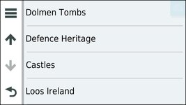
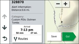
I'm not sure that basecamp/POi loader has a limit. I have the world database of CWGC grave sites and that's just under 25,000 waypoints and it loaded just fine on the XT as a garmin .gpi file though I don't have it loaded at the moment. Of those that are loaded there are 4600 defence heritage sites in Northern Ireland (though this counts individual buildings and features) . 700 Dolmen tombs which includes Cashel's, Souterrains, Portal tombs. It's interesting if you spot something on the map at times just to visit it. Some are more underwhelming than others :D. I also have about 800 castles covering UK and Ireland loaded and 1206 public loos covering the Island of Ireland.......these are proximity alerted. You can make your own little Icon's for these things as they appear on the Zumo but you are restricted to 24X24 pixels in bmp format.

Castles.jpg Defence Heritage.jpg Dolmen Tombs.jpg Loos Ireland.jpg

You can easily get poi's off OSM mapping using QGIS. I recently sent a file of 870 Ice cream shops in the netherlands to a chap looking for that information. That's how I got the Irish Loo's and the GB and Ireland Castles. The Defence heritage stuff and Ancient monuments came from Irish and Northern Irish government heritage mapping websites.

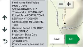
MyRoute app limits POI list to 10,000 waypoints (which is plenty) but only supports Lat Long and a short description. Garmin allows extensive narrative describing each POI and it appears on the Zumo XT for you to read. I believe that the XT2 and XT3 have the capacity to read the notes to you? In any case any information included in the source file of the .gpi file is pulled through to the Zumo.

1792341571741.jpg

1792341624279.jpg
 
Thank you- very comprehensive list!
Still, no contest!
over 348, 000 loaded and still not hit the buffers!!!!:D
Icons - I also make my own but up to 32x32 and in colour.
All such fun!


Back
Top Bottom