A Rothehithe wander

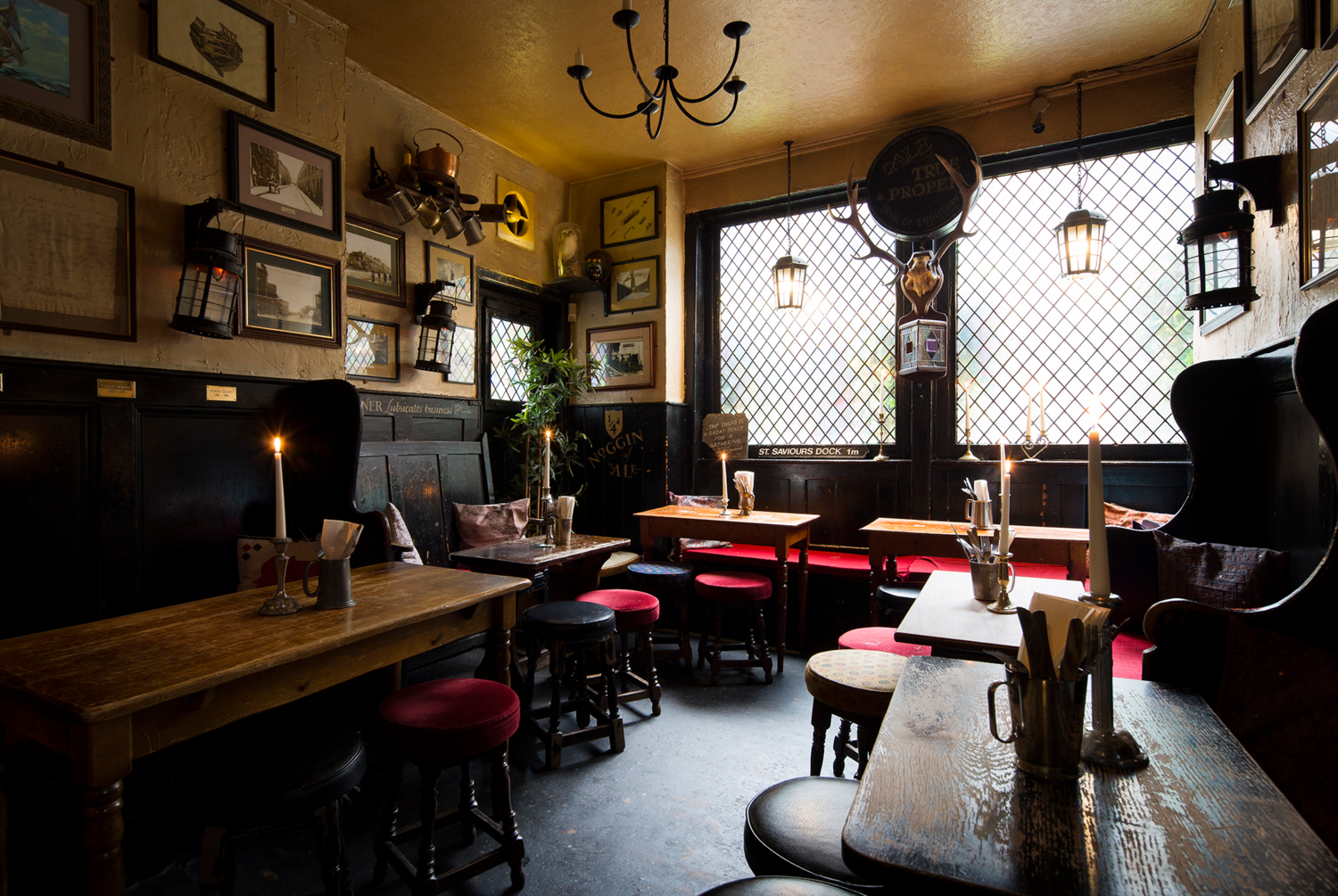
The pub being shut, caused me to look at the signpost:

IMG_7864.jpeg

And take the small alley alongside the pub:

IMG_7865.jpeg

This brought me to the entrance of the former Greenland Dock, with its large hydraulic capstan:

IMG_7867.jpeg

IMG_7870.jpegIMG_7869.jpeg

 
Last edited:
Strictly speaking, this brought me to the end of my Wander. In essence I / we have wandered along the edge of the peninsula from west to east, following the river as it bends around from the Angel.

IMG_7871.jpeg


But, I still had unfinished business. It was too early to wait until 17:00 for the Ship & Whale to open, but I guessed that if I wandered back to the Blacksmith’s Arms, I’d be there a little after 16:00 when it would be open.

I wasn’t disappointed. It’s an excellent ‘locals’ pub and very friendly:

IMG_7875.jpeg
IMG_7874.jpegIMG_7876.jpegIMG_7873.jpeg

From there, I hopped onto the C1 bus and off again at Rotherhithe station for the train home:

IMG_7878.jpeg

A good day out.

 
Last edited:
Leaving the chuch, it’s but a short wander to the Mayflower pub, very close to the Brunel Museum. I have been to the museum before and is anyway shut on Thursdays, so I missed it out but plan to go back there later in the year:

View attachment 488102
View attachment 488109
View attachment 488108

The Mayflower and lunch:

View attachment 488107
View attachment 488103View attachment 488104View attachment 488105View attachment 488106

Pub wise, the beer is a big improvement over Sam Smth’s, so I reverted back to bitter. Of course it’s popular with tourists, so it will be very busy in high summer.


I suspect that when the Pilgrim fathers, who were of course yorkshiremen from Austerfield, went in that pub their first words would have been "how much?"
 
Strictly speaking, this brought me to the end of my Wander. In essence I / we have wandered along the edge of the peninsula from west to east, following the river as it bends around from the Angel.

View attachment 489572


But, I still had unfinished business. It was too early to wait until 17:00 for the Ship & Whale to open, but I guessed that if I wandered back to the Blacksmith’s Arms, I’d be there a little after 16:00 when it would be open.

I wasn’t disappointed. It’s an excellent ‘locals’ pub and very friendly:

View attachment 489574
View attachment 489575View attachment 489576View attachment 489577

From there, I hopped onto the C1 bus and off again at Rotherhithe station for the train home:

View attachment 489578

A good day out.
Good stuff wapping; looking at your google map am i right in assuming that cable street across the river was the same cable street involved in the disturbance yours ago with the facists.
 
Not at all. It’s interesting to hear about bits (large and small) that go on around these London projects.

The church you are maybe thinking of is, I think, St Dunstan’s which is allowed to fly the Merchant Navy’s Red Ensign flag. There are several other churches and charitable institutions dating back to when the area was a vast docks, several dealing with specific different nations that made up the seafarers.

Somewhat stupidly, I missed seeing the Norwegian seafarers’ chuch in Rotherhithe! There’s a Finnish church nearby, too.

The church spires (all different) also acted as navigation points for ships using the river, radar and GPS not being dreamed of.
Thank you for the 'wander' post @Wapping ..... really fascinating to learn about a city from someone with a clear interest in the place where they live.
As an aside, I believe that the orientation of the Anglican Cathedral in Liverpool, unusual in that it is on a North/South rather than the traditional West/East orientation, was to also aid maritime navigation... a similar purpose to the spires referenced in the post above. Due to the shape of the site where the Cathedral stands it could only have been built in that orientation, however I understand that the site was selected specifically for that reason, such that the Cathedral would be elevated and 'broad side' on to the Mersey allowing maximum visibility of the landmark from the water, rather than seeking an alternative site elsewhere in the city which would have allowed the traditional orientation.
 
...swiftly followed by " What a shithole, let's go to America!"
Bawtry, which is about 3 miles from Austerfield ( home of the pilgrim fathers)
AS you enter Bawtry there is a big sign proudly stating that it was a 12 century port

I never have worked out why the daft twats walked to London to sail to USA when a port was 3 miles away
 
I’ll go back at some point, to visit the missing pub and to see a bit more, not least the Norwegian church and more of the Surrey Quays and Greenland Dock, along with the nature reserve.

But first I believe a West End pub crawl might be on the cards….
 
This website is very interesting too with other links to other areas of what a lot of people now consider to be London.


What's surprising in the great scheme of things, until relatively recently London itself was quite a lot smaller when a lot of these places that we now consider to be parts of the capital were built. Large portions of the home counties being enveloped by the expansion of the metropolis

 
Just caught up. Great read about part of a place I've visited numerous times but don't really know
Must go back sometime but as I age cities hold less of a pull for me
 
Must go back sometime but as I age cities hold less of a pull for me

Let me know if you do please, as I’d be happy to meet up.

London is much quieter than people believe. Yes, the main transport hubs may well be busy in the rush hour and / or Oxford Street on a Sunday lunchtime. But, the capital’s a huge area and its eight million plus inhabitants are not all out on the streets at once.
 
This website is very interesting too with other links to other areas of what a lot of people now consider to be London.


What's surprising in the great scheme of things, until relatively recently London itself was quite a lot smaller when a lot of these places that we now consider to be parts of the capital were built. Large portions of the home counties being enveloped by the expansion of the metropolis


I have several prints of old maps of London, framed up. It’s interesting to see the expansion of the city, either as a whole or just (in my case) fairly central. It’s similarly interesting to see the arrival of the canals and then the railways.

I bought this excellent large format book, just recently:

https://www.bbc.co.uk/news/articles/cpqwrqp3yzxo?app-referrer=deep-link

It shows exactly the point your post made, how London has grown and yet, how some streets in the middle have sometimes stayed the same.

Maps and particularly the long history of map making has always fascinated me. How do you map the outline of Australia, when you’ve arrived on a sailing ship? How do you map, by hand, the Himalayan mountains? How did they map America as they opened up the vast continent in a wagon train or by river or on foot?

Maps are power. I read about the Macedonian warrior Alexander the Great, approaching an unknown city which he intended to besiege and conquer. His army brought a prisoner to Alexander’s tent who claimed he could draw an accurate map of the city. Alexander had the man draw it at once. When finished, Alexander had the man killed, as he (Alexander) had a map and nobody else could now get one.
 
Last edited:
On being posted to Stoke Newington in 1981 I looked it up in my book of English place names to be informed that it meant 'clearing in the forest'. On arrival I noticed there weren't many trees left 🥴
 
I've also seen London described as 23 provincial towns and two cities linked by numerous villages; which I thought was quite apt.


Back
Top Bottom