I like most who have a Garmin Zumo XT connected the explore app to the unit when I first got it only to discover that the Explore website was woeful (spoiler alert it isn't much better  ) and the app wasn't far behind and not really for motorcycle automotive use (It won't route on highways/motorways where bicycle use is not possible) . So I disconnected the Zumo XT from the explore app and never bothered with it again concentrating on MRA and Basecamp for route planning. Which to save you a read are still by far the best options.
I'd forgotten about the app and a couple of weeks ago I opened it up again and it had been updated at the end of March. So I was curious to see if things had improved in the "Garmin Explore" world so I had a bit of a play.
The Explore Website.
One of the things that used to bug me was that the website version of explore drew straight lines between the route points that you put in place to create a route and relied/still relies on the Zumo XT routing between the start intervening shaping points and the end. If you inadvertently finished the route it was difficult to start it again, if you decided you wanted to insert extra distance, and you only knew what you were getting when the route was calculated by the XT unit.
Now it seems (or it was always so and I wasn't paying attention) if you inadvertently stop route creation if you grab the last point with your mouse you can pull it in the direction of travel and "Ghost" points appear behind it that you can activate by clicking on them to shape the route. This tends to ensure that you have loads of shaping points on your route which means its likely to go "exactly" were you want your route to proceed. So i think that the explore website has improved a little with regard to making routes. It does not form tracks however, that can be useful in checking routes.

The Explore App.
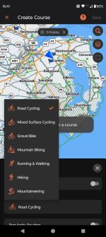
The explore app is not designed for motorcycle use however, if you have it on your phone it gives you access to your Explore library and collections if you have not enabled the link to these in your XT (and I would strongly advise that you don't if you don't want tracks and routes all over your XT map if you have inadvertently turned on your Explore Library and are out of 4g or wifi connection to resync with the server) This means that you have access to routes and tracks in your library that you can send to your XT via the drive app. This could be useful as a backup to other routing applications that you may have. The routing aspect of the explore app has been much improved and is very easy to use. The "gotcha's"of the old app were two fold (unless I'm mistaken) it only produced tracks (called courses in the app no doubt a nod to its intended use for cycling and hiking) and it did not route via roads not suitable for cycle use i.e. motorways and highways. Its a shame that no routes on highways is still the case as the apps routing interface is now very easy to use. However the app can now produces routes (formed by all the points you input to create the track) so I though I'd try it.

I created a course (track) to ride last Thursday. Quite long about 220 miles door to door. The app now gives you the option of saving the course (track) as a track and a route. This is handy as if you put a shaping point before the motorway section and just after the Zumo XT will route along the fastest route i.e. the motorway. You can see above the raw track avoids the motorway.


Sent both the route and the course/track to the XT in the normal way.
You can then make sure the route follows the track/course you've created by making the track visible on the XT map using the tools on the XT. This illustrates the XT's fastest time logic as it will take you down an A road and back up a B road adding miles to your Journey (and time) if you don't place a shaping point on the twisty B128 as intended here. That said, its easy on the XT to plonk an additional shaping point on the preferred route.


All fixed and ready to ride it performed flawlessly and was a mixture of town roads, motorway, A,B,C and unclassified roads gravel roads and two border crossings
Is there a use case for the explore app? Well for routing (except the issues with highways) its quicker and easier than using the XT itself. For creating "courses" /tracks and routes you can do this without 4g and/or WIFI as long as you have the Topo Active maps downloaded for the area you are travelling in and any routes created can be sent directly to the XT using Garmin Drive. If they put a switch on the app to enable highway routing for motorcycles it would be a great little app. As it is if you wanted to tour and completely avoid motorways it would be very easy to achieve using this app.
Shame that Garmin don't fix the Explore app for the XT or let us try tread.
) and the app wasn't far behind and not really for motorcycle automotive use (It won't route on highways/motorways where bicycle use is not possible) . So I disconnected the Zumo XT from the explore app and never bothered with it again concentrating on MRA and Basecamp for route planning. Which to save you a read are still by far the best options.I'd forgotten about the app and a couple of weeks ago I opened it up again and it had been updated at the end of March. So I was curious to see if things had improved in the "Garmin Explore" world so I had a bit of a play.
The Explore Website.
One of the things that used to bug me was that the website version of explore drew straight lines between the route points that you put in place to create a route and relied/still relies on the Zumo XT routing between the start intervening shaping points and the end. If you inadvertently finished the route it was difficult to start it again, if you decided you wanted to insert extra distance, and you only knew what you were getting when the route was calculated by the XT unit.
Now it seems (or it was always so and I wasn't paying attention
) if you inadvertently stop route creation if you grab the last point with your mouse you can pull it in the direction of travel and "Ghost" points appear behind it that you can activate by clicking on them to shape the route. This tends to ensure that you have loads of shaping points on your route which means its likely to go "exactly" were you want your route to proceed. So i think that the explore website has improved a little with regard to making routes. It does not form tracks however, that can be useful in checking routes.The Explore App.
The explore app is not designed for motorcycle use however, if you have it on your phone it gives you access to your Explore library and collections if you have not enabled the link to these in your XT (and I would strongly advise that you don't if you don't want tracks and routes all over your XT map if you have inadvertently turned on your Explore Library and are out of 4g or wifi connection to resync with the server) This means that you have access to routes and tracks in your library that you can send to your XT via the drive app. This could be useful as a backup to other routing applications that you may have. The routing aspect of the explore app has been much improved and is very easy to use. The "gotcha's"of the old app were two fold (unless I'm mistaken) it only produced tracks (called courses in the app no doubt a nod to its intended use for cycling and hiking) and it did not route via roads not suitable for cycle use i.e. motorways and highways. Its a shame that no routes on highways is still the case as the apps routing interface is now very easy to use. However the app can now produces routes (formed by all the points you input to create the track) so I though I'd try it.
I created a course (track) to ride last Thursday. Quite long about 220 miles door to door. The app now gives you the option of saving the course (track) as a track and a route. This is handy as if you put a shaping point before the motorway section and just after the Zumo XT will route along the fastest route i.e. the motorway. You can see above the raw track avoids the motorway.
Sent both the route and the course/track to the XT in the normal way.
You can then make sure the route follows the track/course you've created by making the track visible on the XT map using the tools on the XT. This illustrates the XT's fastest time logic as it will take you down an A road and back up a B road adding miles to your Journey (and time) if you don't place a shaping point on the twisty B128 as intended here. That said, its easy on the XT to plonk an additional shaping point on the preferred route.
All fixed and ready to ride it performed flawlessly and was a mixture of town roads, motorway, A,B,C and unclassified roads gravel roads and two border crossings
Is there a use case for the explore app? Well for routing (except the issues with highways) its quicker and easier than using the XT itself. For creating "courses" /tracks and routes you can do this without 4g and/or WIFI as long as you have the Topo Active maps downloaded for the area you are travelling in and any routes created can be sent directly to the XT using Garmin Drive. If they put a switch on the app to enable highway routing for motorcycles it would be a great little app. As it is if you wanted to tour and completely avoid motorways it would be very easy to achieve using this app.
Shame that Garmin don't fix the Explore app for the XT or let us try tread.